16°19'60" N
61°42'0" W
~26m asl
14:07 (AST - UTC/GMT--4)
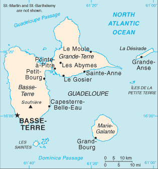
La Ramee River (La Ramee River) is a stream (class H - Hydrographic) in Guadeloupe (general), Guadeloupe [ France ] (North America) with the region font code of Americas/Western Europe. It is located at an elevation of 26 meters above sea level and its population amounts to 14,892.
La Ramee River is also known as Petits Ilets, Petits Islets, Petits Îlets.
Its coordinates are 16°19'60" N and 61°42'0" W in DMS (Degrees Minutes Seconds) or 16.3333 and -61.7 (in decimal degrees). Its UTM position is PD30 and its Joint Operation Graphics reference is NE20-15.
Current local time is 14:07; the sun rises at 08:54 and sets at 21:01 local time (America/Guadeloupe UTC/GMT-4). The standard time zone for La Ramee River is UTC/GMT-4
In 2024 DST starts on - and ends on -.
A Stream is a body of running water moving to a lower level in a channel on land.
|
Advertisements:
Advertisements:
|
Weather La Ramee River (Cloud cover, Temperature, Wind speed and Precipitation mm probab.)
Sat
Apr 27
~0.4 l/m2 13%
26 °C min
28 °C max
24 km/h
Thu Jan 1
|
Sun
Apr 28
~1 l/m2 48%
26 °C min
28 °C max
21 km/h
Thu Jan 1
|
Mon
Apr 29
~3 l/m2 27%
26 °C min
28 °C max
22 km/h
Thu Jan 1
|
Tue
Apr 30
~2 l/m2 20%
26 °C min
28 °C max
24 km/h
Thu Jan 1
|
Wed
May 1
~3 l/m2 35%
27 °C min
28 °C max
27 km/h
Thu Jan 1
|
Thu
May 2
27 °C min
29 °C max
27 km/h
Thu Jan 1
|
|
|
Petits Ilets (Guadeloupe (general)) 7 day forecast
Map and Photos La Ramee River
--- There are no comments yet ---
Add a new comment:
|
Members area
Guadeloupe [ France ] (Overseas Department):
Advertisement
GPS points near La Ramee River
GPS points from Guadeloupe [ France ] (Overseas Department)
|

 Pointe Caraibe (1 km)